


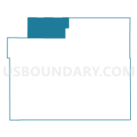
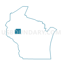
SAMPSON - T 1 Voting District, Chippewa County, Wisconsin
About
Outline

Summary
| Unique Area Identifier | 692656 |
| Name | SAMPSON - T 1 Voting District |
| County | Chippewa County |
| State | Wisconsin |
| Area (square miles) | 68.13 |
| Land Area (square miles) | 62.40 |
| Water Area (square miles) | 5.74 |
| % of Land Area | 91.58 |
| % of Water Area | 8.42 |
| Latitude of the Internal Point | 45.24658610 |
| Longtitude of the Internal Point | -91.42144650 |
Maps

Graphs
Select a template below for downloading or customizing gragh for SAMPSON - T 1 Voting District, Chippewa County, Wisconsin


Neighbors
Neighoring Voting District (by Name) Neighboring Voting District on the Map
- BIG BEND - T 1 Voting District, Rusk County, WI
- BIRCH CREEK - T 1 Voting District, Chippewa County, WI
- BLOOMER - T 1 Voting District, Chippewa County, WI
- CHETEK - T 2 Voting District, Barron County, WI
- CLEVELAND - T 1 Voting District, Chippewa County, WI
- DOVRE - T 1 Voting District, Barron County, WI
- New Auburn - V 1 Voting District, Chippewa County, WI
- New Auburn - V 2 Voting District, Barron County, WI
- RUSK - T 1 Voting District, Rusk County, WI
- WASHINGTON - T 1 Voting District, Rusk County, WI
Top 10 Neighboring County Subdivision (by Population) Neighboring County Subdivision on the Map
- Chetek town, Barron County, WI (1,644)
- Bloomer town, Chippewa County, WI (1,050)
- Sampson town, Chippewa County, WI (892)
- Cleveland town, Chippewa County, WI (864)
- Dovre town, Barron County, WI (849)
- New Auburn village, Chippewa County, WI (528)
- Rusk town, Rusk County, WI (525)
- Birch Creek town, Chippewa County, WI (517)
- Big Bend town, Rusk County, WI (358)
- Washington town, Rusk County, WI (339)
Top 10 Neighboring Place (by Population) Neighboring Place on the Map
Top 10 Neighboring Unified School District (by Population) Neighboring Unified School District on the Map
- Bloomer School District, WI (7,260)
- Chetek School District, WI (6,980)
- Bruce School District, WI (3,702)
- Lake Holcombe School District, WI (2,687)
- New Auburn School District, WI (1,808)
- Weyerhaeuser Area School District, WI (1,157)
Top 10 Neighboring State Legislative District Lower Chamber (by Population) Neighboring State Legislative District Lower Chamber on the Map
- Assembly District 67, WI (58,722)
- Assembly District 75, WI (54,961)
- Assembly District 87, WI (52,707)
Top 10 Neighboring State Legislative District Upper Chamber (by Population) Neighboring State Legislative District Upper Chamber on the Map
- State Senate District 23, WI (176,958)
- State Senate District 29, WI (167,310)
- State Senate District 25, WI (162,546)
Top 10 Neighboring 111th Congressional District (by Population) Neighboring 111th Congressional District on the Map
Top 10 Neighboring Census Tract (by Population) Neighboring Census Tract on the Map
- Census Tract 10.02, Barron County, WI (5,572)
- Census Tract 111, Chippewa County, WI (4,077)
- Census Tract 9603, Rusk County, WI (2,245)
- Census Tract 9602, Rusk County, WI (2,028)
Top 10 Neighboring 5-Digit ZIP Code Tabulation Area (by Population) Neighboring 5-Digit ZIP Code Tabulation Area on the Map
- 54724, WI (7,174)
- 54728, WI (6,139)
- 54757, WI (3,314)
- 54732, WI (2,924)
- 54745, WI (2,261)
- 54895, WI (910)